Wednesday 29 February 2012

Fox Glacier Village

Bush walk in the rain
A day of rest.  The expected drizzle started at breakfast but it wasn’t heavy so we decided to go on our planned walk around Lake Matheson, rain or no rain.  The lake was only a few km away, pictured in all the brochures showing brilliant reflections of snow-covered glacial peaks.  There was of course no snow on the visible peaks, cloud covering most of the mountains and raindrops spoiling the reflections but it was quite atmospheric.  A nature trail (I mean a bush walk) under umbrella, a fine day for the ducks.  With stops for photos, the walk took a couple of hours and was finished off with coffee in the lake’s up-market restaurant.  The remainder of the day really was rest (well rest for John, that was): washing and ironing (guess who did that), editing pictures, sending some e-mails (another motel with dire internet connection) and a good meal out in the evening.
Lake Matheson
View of views, Lake Matheson


Ducks in a row

Tuesday 28 February 2012

Hokitika to Fox Glacier


Lake Ianthe in Scenic Reserve
Our original plan had been to go walking around in the Hokitika area today but the forecast of rain tomorrow persuaded us to head off to Fox Glacier in time to catch a glacier walk there in the afternoon. Our journey south went through a succession of  ‘Scenic Reserves’, presumably a step down in status from National Parks.  In fact the scenery to be seen from the road was mainly forest rising on either side of us or fern covered cuttings.  We passed through Franz JosefTownship which serves the neighbouring, more famous and more touristy, Franz Josef Glacier, with echos of an Alpine tourist village without the skiing and snow, and arrived at the comparable Fox Glacier Township.

Looking back down the glacier valley - that's Mandy
on the right
We had booked ourselves on the afternoon ‘Foxtrot’, a  4-hour guided visit to the glacier.  The tour company kitted us out with boots, crampons for later use and more substantial jackets than our own.  A bus took us to the glacier car park from where our guide, Mandy, led us in a group of a dozen to the side of the glacier some 40 minutes away along a track up the debris filled valley floor.  Had we arrived half a century earlier then this entire part of the valley would have been filled with the glacier to a depth of a couple of hundred feet.  The first part of the track is open to the public but beyond the glacier terminus there is no public access; only guided tours are permitted onto the glacier.

Glacier terminus - click to enlarge and look for the tiny people
on the public viewing gallery, to the left of face of the terminus 
Fox glacier moves quickly (5 – 10 m per day in parts, less at the terminus).  The terminus ice is only some 80 years old.  We climbed up onto the ‘flat’ of the glacier via steps cut in the ice by the guide team and kept in shape by every guide.  Mandy carried an ice axe which she used to repair and cut new steps in the ice as we went. This week’s steps were different from last week’s because of the movement of the glacier.  The flat isn’t flat but eaten away by melt channels, holes, cracks and other features.  It’s covered with small, sharp stones, broken off the surrounding peaks.  Each stone has sunken a little into the top, absorbing more heat than the surrounding ice. 
Climbing up onto the glacier
Foxtrotters on the glacier plateau
On several occasions during our visit we heard and sometimes saw stones cascading down on the far side of the glacier as the ice moved.  This left us with the impression that, on the whole, the glacier was not a particularly safe place to be!  The guide’s instructions that we should follow where she walked in single file seemed sensible.  There were little pools of blue water all around.  We each had a walking pole and this could be poked into the holes.  Sometimes it went down only a little; in some holes it could be poked in down to the handle.   Mandy showed us one strip of water only a few feet away that a stone dropped in sank down out of sight.  It was a crevasse filled with water.  We hadn’t expected so much water to be flowing in various streamlets that seemed to appear and disappear almost at random.  We were visiting at the end of summer.  Our short crampons, effectively four spikes in front of each boot heel, were very effective in giving grip on the slightly soft ice.
Ice cave called a compression arch
Our ‘Foxtrot’ was limited to the lower part of the glacier but it lasted quite a while and we had many of the features there pointed out.  The tour was well organised and our guide was good.  We were the only native English speakers in our party so she seemed happy to answer all our questions since very few came from any of the others.   All told, a fascinating excursion but we haven’t any desire to become glaciologists.

Monday 27 February 2012

Cape Foulwind to Hokitika


Seal Colony (if you look really hard, there are a couple of seals in the shot)
John got very excited today - rated it one of the best days ever.  Rain disappeared overnight. Drove back to Tauranga Bay where the waves were still rolling in, despite the calm weather, and went on a walk to the Seal Colony, Lighthouse and back. The Seal Colony is just a short walk from the Bay and is a popular tourist spot. The seals are New Zealand fur seals which were almost wiped out by Maoris and settlers but are now making a come back. At first it was hard to spot them, they are so well camouflaged against the rocks, but gradually the eye learns to pick them out. Only cows and calves are there at this time of year; the bulls, having done their bit, have disappeared off to sea.

Looking back to Cape Foulwind
Weka
From the Seal Colony, the walk continued along the cliffs to the Cape Foulwind lighthouse. The sun came out, the views were terrific and the rolling waves were splendid. John was in photographer heaven. Saw several wekas close to the path. This is one of New Zealand's flightless birds, a bit like a kiwi but, unlike the kiwi, not rare and not reclusive. They've even learned to scavenge in picnic sites. Rated this best equal walk with Mahinepua.

West Coast scenery
After an ice-cream in the car park, we badeTauranga Bay a reluctant farewell and set off south, down the West Coast. Lonely Planet rates this drive as one of the 10 most scenic drives and it is indeed splendid. The sea is a beautiful turquoise and the rollers tumble into a series of  magical sandy bays,  peppered with offshore stacks and rocks. More potographer heaven but not enough stopping opportunities.

Pancake Rocks
Our next stop was Punakaiki and the Pancake Rocks. These curious limestone rocks have been formed in layers that look like stacks of pancakes - hence the name. In between the stacks there are several blowholes, coves and cliff arches, making fascinating viewing as the sea surges in between and steams up the blow holes.

Pancake Rocks Blowhole

Cameron Beach
From Punakaiki we continued down this beautiful coast, past Greymouth, where we didn't linger. Made a brief stop at Camerons, where we sat on the driftwood littered  beach watching the surf and looking out for, but not seeing any, little blue penguins.

Hokitika
Reached our destination, Hokitika, a quaint, sleepy little town that had been a bustling port in days gone by when gold fever hit the area and when trading with Australia was easier than with the east coast of New Zealand, the mountains being such a barrier. Took a wander round the town, before dining in the Cafe de Paris.

Sunday 26 February 2012

Kaiteriteri to Cape Foulwind

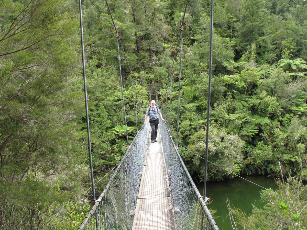
Suspension Bridge over Motueke River
Left Kaiteriteri in sunshine, arrived at Cape Foulwind in drizzle. Was to be a day of mountains, forests and rivers and a marked drop in temperature. Today's route took us through valleys, up and over the Hope Saddle, then down through the Buller Gorge to the sea.

Started off midst orchards and hop fields along 'Old Highway 61', with Tasman Mountains in the distance. (Never did find out if and where there is a new Highway 61.) Meandered along the Motueke river valley, past several suspension bridges leading into the Kahurangi National Park, the mountains getting closer until, over a rise, we got our first mountain panorama. Continued to follow the Motueke until we reached Kohatu where we joined our old friend, Highway 6, the main road from Nelson to the West Coast.

First mountain panorama (Arthur Range)
The road climbed up and over the Hope Saddle, at the top of which there was a lookout and information boards about the history of this route. In 1871 a winding, precipitous track was cut through the bush over Hope Saddle, opening up the first  route through the mountains from Nelson to the West Coast. In 1879 the first horse drawn vehicles started using it but the route remained long and hazardous with many icy rivers to be forded on the way.

Buller River
Once over the Hope Saddle, the road meets the Buller River, which rises further west in the Nelson Lakes National Park, and the highway follows the Buller all the way to the West Coast, through two impressive gorges. We stopped in the Upper Buller Gorge to cross the longest swing bridge in New Zealand (110m long and 17m high) into the Heritage Forest Park on the far side, where we went for a walk in the bush. Sights seen on the walk included the White Creek faultline, epicentre of a 1929 earthquake, when the ground was instantly thrust upwards by 4.5 metres, an old gold mine shaft and other gold mining relics (but no gold), and the Ariki falls.
Swing Bridge over Buller Gorge

In the Upper Buller Gorge, the road runs along the top of the gorge, eventually winding down to Inangahua Junction, where another highway peels off to make its way south west to the coast at Greymouth. Our Highway 6 continues along the Buller, entering the Lower Buller Gorge, running along the bottom of the gorge this time, hugging the impressively steep cliffs. Eventually it all flattens out as the river reaches the small coastal plain and flows into the Tasman Sea at Westport.

Lazy Seal Chalet, Cape Foulwind


Tauranga Bay
We continued past Westport to the ominously named Cape Foulwind* where we had rented a chalet for the night. Lovely wooden chalet with a huge living area and separate bedroom, set amongst well kept and colourful gardens. Would have been nice to sit out on the deck with a glass of wine but, alas, it was raining by now. Settled in, then went for dinner at the newly re-opened Bay House Café, 3 km away at Tauranga Bay. This restaurant had been recommended to us but my internet research discovered that it had closed last year. We were delighted to hear from our landlady that it had just re-opened 3 weeks ago. The new owner is a Scots lady. We had an excellent meal, overlooking the Bay, with waves rolling in from the sea, crashing on the beach. We hope to revisit this area tomorrow, as there is a walk along the coast, past a seal colony and a lighthouse. Weather forecast is good so here's hoping.

* Extract from the Lonely Planet Guide to New Zealand . . . . The Maori called the cape Tauranga, meaning "sheltered anchorage". The first European here was Abel Tasman in December 1642, naming it Clyppygen Hock (Rocky Point). When James Cook moored the Endeavour here in March 1770 a furious storm made it anything but a 'sheltered anchorage'; hence the cape's modern name. 

Saturday 25 February 2012

Abel Tasman National Park

Split Apple Rock
Early start to catch the 9.15am Sea Shuttle from Kaiteriteri. Were able to walk along the beach from our B&B in Little Kaiterteri to the main beach in Kaiteriteri, from which the water taxis operate. It was a lovely sunny morning. We opted to take the shuttle to Torrent Bay and then walk through the park to Bark Bay, where the shuttle would pick us up later in the afternoon. Scenery gorgeous as we motored up the coast towards the park. The boat detoured into a bay to give us a view of the iconic Split Apple Rock.

Torrent Bay

Boat put in at Coquille Bay and Anchorage, to let people off, then the next stop was Torrent Bay where we disembarked. Took a walk along the beautiful sandy beach first, before setting off on the path through the woods to Bark Bay, some 7km further on. Lovely walk through lush green rainforest, with occasional glimpses of the sea. Crossed seven bridges over mountain streams, one of which was a picturesque suspension bridge. 

Abel Tasman track
Torrent Bay
Suspension Bridge
Took a detour labelled Sandfly Beach, down a steep track, only to find that the path ended on rocks, with a view of the on the other side of an estuary. Another detour to a viewpoint at South Head was more rewarding. Finally our path wound back down to Medlands Beach, just a short distance from Bark Bay, the end of our walk. Lunched on the beach at Medlands, then walk over to Bark Bay to relax on the beach until it was time to take the Sea Shuttle Back home. Sun kept popping in and out of the clouds, so wasn't quite hot enough for swimming but we both went in for a paddle.
Bark Bay

Sea Shuttle picked us up from Medlands Beach at 4.30pm and headed back to Kaiteriteri, picking up people from Torrent and Anchorage on the way. It was a fabulous day.

Friday 24 February 2012

Renwick to Kaiteriteri

Havelock Harbour
Left the vineyards on Highway 6, heading for Nelson. Road travelled through rural countryside first, with lots of sheep, cattle and some deer, but all against a backdrop of mountains. Paused at Havelock, to wander round the harbour. Havelock is at the end of one of the many inlets that form the Marlborough Sounds and is a centre both for pleasure boating and mussel fishing (it's the Greenshell Mussel Capital of the World). Missed a trick here as, unbeknown the John, Ernest Rutherford went to school in Havelock and there is a memorial to him in the town, which we didn't see.

South Street, Nelson
From Havelock, the road climbed up the Pelorus river valley, over the Rai Saddle and down through forests to the coast on a very steep and twisty road. Drove along the coast and paused in Nelson to look at the Cathedral  (reputedly, but not obviously, art deco in style) and the quaint workers cottages in South Street, billed as the oldest fully intact street in NZ. John phoned the iSite to ask where there was a memorial to Ernest Rutherford, NZ's only Nobel Prize winner, to be told that we'd missed the one in Havelock but that the main one is in Brightwater, just outside Nelson. Added this to our route.

Ernest Rutherford Memorial
After Nelson, we had lunch with Betty Williamson, an old family friend of Aenea's who lives in Richmond, a town just outside Nelson. We had a delightful visit with Betty and it was super to see her two daughters, Fiona and Heather, who called in to say hello. From Richmond we took a detour to Brightwater, to view the aforementioned memorial to Ernest Rutherford. This was in the form of a spiral, with a sequence of information boards, detailing his life and works.

Kaiteriteri Beach
 From Brightwater we rejoined the highway and made our way to Kaiterteri. Checked in to our B&B and were disappointed to find that the private boat trip I had provisionally arranged with the B&B owner was no longer available, since the owners of the B&B had gone away unexpectedly, leaving another couple to hold the fort for them. We were, however,  able to book a trip with the Sea Shuttle, one of several companies that operate water taxis from Kaiteriteri into the Abel Tasman National Park. Dinner in the Beached Whale, with a background of rugby on the TV. (New Zealanders really like their rugby.)

Wellington to Renwick

Sailing out of Wellington Harbour
Woke to driving rain and gale force winds - ideal for a ferry crossing not! Aenea rather subdued at the prospect. Loaded on to the Interislander ferry and bade farewell to Wellington. Despite the weather, views still impressive as we sailed out of Wellington Harbour and into the Cook Strait. Sea was remarkably mild, given the strength of the wind but we were told this was because wind was northerly. Southerly gales are a different story. Lumpy patch in the middle of the Strait, where the two oceans meet.

Some blinks of sunshine as we neared South Island. Lovely rainbow welcomed us as we entered Tory Channel. Relative shelter of the Channel brought everyone out on deck to snap the stunning scenery. Motored down through the channels of the Marlborough Sound. The mountains drop straight down into the sea but, every here and there, there was a little house, perched on the slopes, accessible only by boat.
Tory Channel in Marlborough Sounds

Patches of sunshine as we disembarked at Picton and headed inland. Road climbed up and over some hills, then down into the sunshine of the plains where the countryside became agricultural and soon we were into the Marlborough wine fields.  Vineyards on the plain as far as the eye could see but set against a backdrop of wrinkled mountains both north and south. Soon reached our B&B in Renwick which is in the heart of the wine fields.


Picton
Borrowed bikes from the B&B and, despite the continuing strong wind, cycled off to visit some of the nearby wine cellars. There was a huge number to choose from. First stop was Georges Michel which, as the name suggests, is owned by a Frenchman. Here we had a delicious lunch in the attached French Bistro, before sampling their wines. All delicious with a definite French influence. Selected a bottle of Rosé (the first NZ Rosé we've really liked) as our purchase here.

Cycling in Bladen Vineyard
Next cellar we visited was Bladen. A small "boutique" winery, owned and run by a couple from Wellington who decided to realise their dreams. Tasting was done by the wife, who recounted the story of how they started up and all the hard work they have had to put in. Nice to have the personal touch. Here we were seduced by one of their red wines, a Merlot/Malbec. The most expensive wine we have bought to date and definitely coming home with us.

Marlborough Vineyard with backdrop of mountains
The third cellar we visited, Gibson Bridge, is the smallest cellar in Marlborough and is also a husband/wife concern. This time it was the husband who was running the tasting (while the wife was doing the books) and he was clearly passionate about the quality and individuality of their wines. Their speciality was Pinot Gris, of which they had multiple versions and vintages and it was hard to decide which we liked best but eventually, a bottle of the 2010 Reserve was added to our bicycle panniers.

Having sampled 6 or 7 wines at each of the cellars, it was fortunate that we were not far from the B&B and a bit of R&R before dinner. It was a wonderful afternoon, cycling in the sunshine from vineyard to vineyard, and we saw and met several other couples doing the same thing. The area is very flat and there are lots of cellars close to one another, so it is ideal for cycling. Had dinner at a restaurant nearby. Our B&B hosts were kind enough to drive us there and then pick us up again, so some more wine could be consumed with dinner.

Wednesday 22 February 2012

Wellington

Cable Car


Alas Wellington has lived up to its reputation for wet and windy weather but, nevertheless, we enjoyed our visit there. Our motel was nice and central so we were able to walk around the town without taking the car. Headed first for the Cable Car which took us up the hill to the Botanic Gardens. After a quick visit to the Cable Car Museum, we headed for the Carter Observatory which is located in the gardens. Here there was an excellent exhibition about all things astronomical with some very well done audio visual presentations and a Cooke refracting telescope from the 1860s, much to John's delight. After visiting the exhibition, we saw a show in the planetarium. This was in two parts - first a dramatic but slightly too long film about space travel, then an all too short planetarium display, looking at the stars in the sky above Wellington.
Cooke Telescope


From here we wandered down through the Botanic Gardens, brollies up. Beautiful gardens which we would have explored a bit further had the weather been a bit more clement.  Saw the Peace Flame, which is fire taken from the aftermath of Hiroshima, committed to remain alight until all nuclear weapons have been eliminated from the world. This part of our walk ended at the Begonia House where we stopped for some lunch.

Peace Flame (in centre of pond)
The walk then continued down the hill to the Parliament Building - an elegant building onto which has been attached a 1960s extension, known locally as 'The Beehive'. This could have been an interesting modern building (though John Milne subsequently told us that it's reputed to be an unpleasant building in which to work) but looked somewhat out of place juxtaposed to the older, classical style building. Next we passed Government House, an imposing two-storey wooden building, official residence of the Governor-General, and then we reached the quayside. Walked back along the quayside which has obviously been redeveloped recently, passing some nice looking restaurants, and back to the civic centre to which we had walked the previous evening.


Waterfront restaurant


In the evening (by which time it was raining really heavily), we drove out to the Miramar Peninsula where we had dinner with John Milne and his family and spent a very pleasant evening there.

Tuesday 21 February 2012

Napier to Wellington

Napier Rising from the Ashes
Left Napier on the road to Hastings, pausing at a statue symbolising Napier rising from the ashes.  The road to Wellington runs mainly across expansive flat farm land between two mountain ranges.  We stopped at Danevirke, a town curiously sporting Viking figures, but rejected their offering of cafés.  Motored on to Woodville, a smaller place where every second shop was an antique or bric-a-brac emporium.  They had a nicer selection of cafés too. For a late lunch we drew into a picnic area beside the National Wildlife Centre, some 150 km from Napier, and chanced upon one of the couples who was with us in the minibus on yesterday’s wine tour.  Small country, New Zealand.
  
Agapanthus by the roadside
Road remained relatively flat and straight until we reached Featherstone, then it was up and over the Rimutaka Mountains on a twisty road with dramatic views. Once over the mountains the road ran down beside the Hutt river, passing through a series of satellite towns to Wellington.

View from our Wellington motel window


Reached Wellington at about 4 pm and clocked into our 5-storey, city-centre motel.  5-storeys in an earthquake zone?  Hopefully a ‘modern’ building.  The last big quake here was 1851 or so.  We were very pleased to meet John Milne, a former colleague of Aenea at Aberdeen University, who came round and we walked down-town for a beer and introduction to the city sights.

Monday 20 February 2012

Hawkes Bay Winery Tour


The Mission Estate

Woke to grey skies and rain so took the opportunity to catch up on laundry and writing the blog. Picked up at noon by Grape Escape, the winery tour company. Just six other people, in addition to ourselves and Dave, the guide, so a nice small group. First stop was the Mission Estate. This is one of New Zealand's largest and oldest wineries, founded by missionaries in 1850 ­to make sacramental wine. Originally on the coast, the missionaries got fed up of being flooded, so dismantled their mission building into several chunks, towed them to higher ground, and rebuilt the mission there. It's a nice, old characterful wooden building, set in fine grounds. Here we had our first samples, tasting 1 sparkling, 3 white and 3 red wines from their range. Bought a bottle each of the sparkling wine and the Semillon dessert wine.

Then it was on to the Elephant Hill Estate and Winery. In contrast to the Mission, this is a very modern looking estate - all glass and stainless steel - on the Te Awanga coast. Established by a German businessman, who fell in love wirth the area in 2001. Had an excellent lunch here in their stylish restaurant as well as tasting a selection of 6 of their good wines. Bought a bottle of Sauvingnon Blanc and Syrah.
Elephant Hill wine tasting


Third visit was to Black Barn Vineyards. This is a smaller estate, in the hillsides south of Havelock North. Unlike the Mission and Elephant Hill, they don't export their wine, but concentrate on the home market. Tasted another six wines here and bought a bottle of Pinot Gris.

The fourth and final visit was to Askerne Vineyards, in the same area as Black Barn. Askerne is a single estate winery, committed to producing elegant fine wines. Here the host was as much of a star turn as the wines. He talked us through 13 different wines, describing their nature, comparing them with same grape wines made in other countries, and providing lots of details on taste and appropriate foods to accompany the wines.
Wine tasting at the Black Barn

Our host and sample bottles at the Askerne winery

All this was peppered with jokes and anecdotes, making this the most amusing and enjoyable of our four visits. Bought a bottle of Sauvignon Blanc and Pinot Noir.

All told we sampled over 30 wines and chose what we thought were the best in each estate. We seemed to be remarkably sober at the end of it but we'll see if it catches up with us in the evening.  We'd cooked enough food on Saturday to have an evening in, so no driving at all today.